Sherpani Col and Amphulapcha Pass Trek
Overview
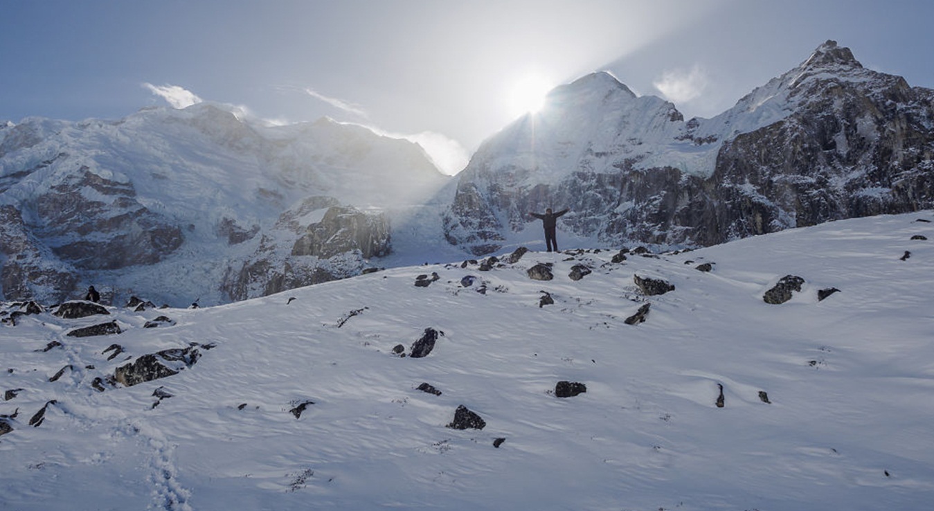
Sherpani Col and Amphulapcha Pass trek is an outstanding trek in the eastern region of Nepal which offers a combination of rich cultural heritage, unsurpassed beauty and biological diversity. This is one of the challenging treks in Nepal this trip takes you to the Nepal’s most difficult cliffs passes Sherpani Col, West Col and Amphu Lapcha Pass. The trail takes you from the steamy lowlands of Tumlingtar on the Arun River, through one of the least frequented areas of Nepal, to the base camp of Makalu. The trail follows the beautiful Barun river valley in the Makalu Barun National Park as well as crossing Shipton pass at 4127 meters before arriving at Makalu Base Camp (4812m). From the last point of this trip offers beautiful views of the south face of Makalu, as well as Mt. Everest, Lhotse and Nuptse are truly regal and fantastic.
This trek is considered as most technical trek and suitable only for sporty people and trekkers need full mountaineering equipment and participant are fit enough to get a sense of adventure to enjoy of this trek. Basically all these passes lie on the three main ridges of Baruntse. The south-east ridge drops down to Sherpani Col at 20,127 ft (6,135m); the south ridge has West Col at 20,154 ft (6,143m), and the west ridge which ultimately joins Ama Dablam dips down to 19,193 ft (5,850m) at Amphu Lapcha.
This trek begins after a one hour flight from Kathmandu, we will arrive in Tumlingtar just above the Arun River. We will follow the traditional Newari trade route along the ridge crest to Mani Bhanjyang. Ascending alone numerous switchbacks and cross suspension bridges, we will see Hindu and Buddhist Gompas and brightly painted Mani walls as make our way to Tashi Gaon, the last village on the trek to base camp. We will walk through a lovely cloud forest and have exceptional views of Makalu and Chamlang. We will cross tow passes and descend into Mumbuk through forest of fir trees and rhododendrons. We will pass through the meadow at Yangle Kharka to Merick past waterfalls cascading for the hundreds of feet on either side of the granite walled valley. We will be well above the tree like at this point in the truly Alpine conditions and will enjoy excellent views of Peak 3, Peak 4, Peak 5 and Chamlang. Depending on how w fell, we will either make our way to Makalu Base Camp at (17000ft) or Hillary Base Camp (17384ft) a bit farther up the glacier. Here we will take well deserved days with plenty of time for exploration. We will continue to Baruntse Base Camp, and then over the West Col, which at 6143m is the highest point of our trek. Outstanding views, we will descend to Panch Pokhari (13284ft) where we will rest by the five holy lakes for a couple of days. After one last push over Amphu Lapcha cross (18958ft) and into the Khumbu Himal, we will take a rest day in Dingboche. Continuing on to Lobuche, you will have the option of a day trip to climb Kalapatthar (18192ft). As we make our way back to Lukla via the Sherpa capital Namche Bazar (11283ft) you will hopefully have the energy to purchase a rug and carry it back to a loved one back home. We will fly from Lukla to Kathmandu, relishing the spectacular views of the Himalaya from the air.
Highlights
- Rim of the Kathmandu valley tsightseeing
- Scenic flight to Tumlintar and Lukla to Kathmandu.
- Trekking on off the beaten track
- Fifth highest mountain in the world
- Tibetan life-style in refugee camps and the mystic Landscape.
- Snow capped Himalayan peaks
- Home of Sherpa, Rai and other ethnic group
- Makalu Base Camp
- Superb Mountain View
- Friendly people and many more
- Full of flora and fauna
- Sherpani Col (6110m), West Col (6135m) and Amphu Lapcha Pass (5845m)
- Tyangboche Monastery
- Namche Bazzar
Trip Summary
| Trip Grade | Moderate to strenuous trail |
|---|---|
| Trip Duration | 26 Nights/27 Days |
| Trip code | NAP-MKL-412 |
| Trip Start/Ends | Tumlintar, Khadbari/Lukla, Kathmandu |
| Maximum Altitude | Amphu Lapcha Pass (5200m) |
| Trip Cost | Prices on request |
| Group Size | Minimum 2 upto 16 persons in one group |
| Accessibillity | 45 minutes fly to Tumlingtar and 35 minutes fly from Lukla to Kathmandu. |
| The Route | West Col, Sherpani Col & Amphu Lapcha Pass (5200m), 5/7-hrs average walking per day, Moderate to strenuous trail.. |
| Season | Sept – Nov / March - April |
| Permit Fee | Per week per person US$ 10 or equivalent convertible foreign currency. |
| Trip Facilities | 3+ hotel in city on B/B and home-stay/camping on mountain. |
Itinerary

Upon arrival at Tribhuwan international airport, welcomed by our representative and transfer to hotel. The remainder of the afternoon is at leisure. A pre trip meeting and briefing will held all together with you at hotel about the daily program activities by company representative and your trip Leader/Guide where you can discuss your final questions all together.
After breakfast the day will start with a guided tour of Kathmandu's historical and spiritual key attractions; including the historic Kathmndu Durbar Square, the famous 'Monkey Temple' (Swayambunath) and then finally visit to Patan Durbar square which is situated the heart of the city constitutes the focus of visitor's attraction. In the evening there will be pre-trip discussion where you can meet your group leader/guide then you can ask any questions you may have
As per the flight schedule you will be transfer to the domestic airport to fly to Tumlingtar. On flying you will overlook range of snow capped peaks of Gaurishanker, Mt. Everest, Makalu, Mt. Kanchenjunga and more other peaks. On arrival at Tumlingtar airport meet our trekking crews. The Tumlintar which is a village town located on a shelf above the Arun River. From the airstrip of Tumlingtar, we walk to Khumal Gaon and immediately turn right and follow the trail that passes to the east of the small lake and temple. This leads onto a ridge, passes the school and begins an ascent between the Arun Koshi and the Sabha Khola. At Dhunge Dhara the climb leaves the ridge and becomes less steep as it contours to the outskirts of Khandbari.
After breakfast at Khandbari we begin our trek to Chichila. On the trek between Khandbari to Chichila the trail emerges between shops onto a ridge, climb to Naya Bazaar, then remains fairly leveled to Mani Bhanjyang (1100m) from here there are two routes we take the better one for which we turn left of the northern end of Mani Bhanjyang, climbs in bamboo forests along the ridge to Arun Than at 1280m, then connect across the hillside, climbing through fields, bamboo groves and big rocks to Sheka. From their Bhotebas we descend a bit to the next ridge, and then follow the crest as it makes some ups and downs through a deep damp forest of rhododendrons and ferns for 1and ½ hours to Chichila.
As our continuing journey from Chichila to Num leads us through the cool and serene forest of rhododendron, oaks and hemlocks as we climb to the top of the ridge, from the top it is almost downhill for two hours to the overnight camp at Num, which is a small village with about fifteen houses and a primary school on the large flat ground, from where we have good view of our route for the next couple of days.
We start our trek with descending incredibly steep and terraced slopes towards the Arun River, nearly 800 meters below. The lower slopes of this narrow valley are densely forested and the paths are quite slippery, after reaching the bottom, cross the suspension bridge across the torrential Arun River, and climb back out of the rain forest, reaching our lunch place at Runruma. Further walk steep climb takes us up to Seduwa a village with a small health post and a primary school nearby we will camp for the night.
This ay is our easy and pleasant day with short walk takes you to rural farm villages, on the gradual trail through the farm fields and terraces, as we come near to Tashi Gaon, it’s an uphill climb for an hour through the millet and rice fields. We will overnight at camp and rest of the time explore around the local village to know the Himalayan lifestyle and ethnic group from this region.
This day we begin our trek to from the last village up to the Makalu and after this village the walk is refreshing for an hour and a half in the beautiful shade of the rhododendron and oaks forest, after leaving the dense forest coming to a summer pastures with traces of temporary made shepherd huts. From here onwards to Kahuma ridge is strenuous uphill climb, as the tree lines declines for the bushes of rhododendron and juniper. We’ll stay here and can be seen Scenic Mountain ranges as well as below valley.
After the superb mountains view and the surrounding landscapes and snow capped peaks, our trek follows a gradual trail with few ups and down as we pass through the Thulo Pokhari and Sano Pokhari. In the heavy snow, the path from here can be quite misleading and it will be arduous to find the trail sometime and further walk cross the pass of Tutu-La at (4075m). We onwards our journey, it is all downhill back to vegetation, a small clearing place for camping in the middle of the woods of pines, hemlock, birch and rhododendrons to reach at Mumbuk for the overnight.
We walk from here is downhill to the enclosed and concealed Barun Valley, one of the least explored area in the eastern Himalayan region of Nepal. This unique landscapes within the Makalu-Barun National Park are some 3,000 species of flowering plants, 440 bird species and 75 species of mammals, including the endangers clouded leopard, red panda and musk deer. As we reach the lush alpine area of Barun Valley the walk is very pleasant with gradual uphill slopes, following the Barun River upstream on the valley gorge towards our camp at Nehe Kharka, one of the summer pastures for the local folks of Tashi Gaon and Nava Gaon.
As our continuing onwards journey crossing the wooden bridge on the Barun River and walk on the boulders, where is a large prayer wall at Ramara, after 2-3 hours walk the vegetation gets sparse, although the rhododendron, barberries, cotoneaster and juniper bushes persist for some time. With a pleasant walk we come nearer to Sherson in sight of the lower Barun glacier and the towering majestic Mt. Makalu. Sherson is also the lower base camp of Mt. Makalu. There are number of stone enclosures at this high grazing ground with outstanding view of host of peaks, including the upper part of Makalu south face, and Mt. Baruntse (7220m) and at Sherson we make camp for the night.
This day we have a have full day rest at the camp for acclimatization and you may visit around some interesting hike and view points to explore, the most scenic walk would be taking a hike on the right side of the camp above for the closer view of Mt. Makalu, Barun Pokhari and the view of the rare face of Everest the Kanshung face with Lhotse. A one hour steep up brings you to the large meadow you can walk farther up to have a greater view of the mentioned peaks and more other peaks of this area and beyond. After exploring the area stroll back to the camp.
A short day we continue to more isolated area towards the higher base camp, which is less than three hour trek above Sherson, at the snout of the Barun glacier, near its glacial pond. Upon arriving at the camp afternoon free for short hike above this camp, a climb on the moraine ridge, for more spectacular views of Mt. Makalu, and of the usual hidden east sides of Lhotse and Everest, which looms above the Barun glacier to the North West. We will spend rest of the afternoon at leisure and preparing for the next big adventure. Some of the porters will set off back with equipment which we do not need to take with us making the load as light as possible to overcome the traverse over Sherpani col and beyond.
Our journey from here heads westwards to camp just below Makalu west pillar, as the altitude gains slowly, we take our time with enough breaks in this high terrain our walk follows a path which climbs an ablation valley on the west side of the Barun glacier. Following this valley onto the glacier we make our way over the boulder-strewn caves and ice to a camp known as Puja camp below the towering Mt. Makalu's west Pillar. Our strenuous trek on the glacier is rewarded with unique views of Lhotse and the rare Khangsung face of Mt Everest.
As getting more adventures and higher elevation we are leaving our camp the path follows to a steep climb up the rocky slopes of the Barun's west bank, until a line of cairns leads us into the valley where two small glaciers are fed by the slopes of the Sherpani Col. We will make our camp beneath the ice cliffs at the terminus of these two glaciers.
This day is an important rest day for well acclimatization before the hard high climb and steep descend. At this altitude offers superb views of the giant west face and west Pillar of Makalu. Here our expert guides will check the route and make the pass accessible by fixing ropes en-route pass.
After Sherpani Col we leave the camp and climb on the icy snout of the Sherpani Glacier, three separate Col's give access to the cirque, we will choose the most appropriate of these routes, according to the prevailing conditions, our climb follows on steep snow covered slopes, with the back-up of the fixed ropes which we had set up on the previous day. From the Col we will rope up to cross the glacier to the rocky crest of the West Col. This stunning cirque is framed by the sweep of Baruntse's icy ridges to the north, the vast cliffs of Makalu, the wall of Chamlang to the south and the shapely spire of Ama Dablam ahead of us to the west. We will be having our packed lunch on the world's highest picnic spots, in the meantime our guides will scout the safe route down the West Col. After a break a descent from the Col on fixed lines leads us to the Hongu Glacier, and end our long hard day with a gradual walk over snow slopes down to our camp on the moraine.
Our journey leads to our next adventure over the Amphu Lapcha before we head towards the main busy trail of Lukla, Namche Bazaar and Thyangboche. Walk follows across the wide reaches of the upper Hongu Basin towards Kang Leyamura a (6430m) peak to the west. Following the rocky glacier in the beginning, then towards old and more recent moraine deposits, we reach the beautiful Panch Pokhari meaning 'five ponds' and make our camp near to the largest pond at the foot of our final pass Amphu Lapcha (5780m).
Another well earned rest day, which gives us a break to pull back our strength back for the final assault over the last big pass. Either relaxing or for the energetic people there is an opportunity to climb smaller hills behind the camp for the excellent views of the Hinku Glacier and the Mingu-La.
This day, we have a short day walk up to high altitudes to Amphu Lapcha high camp. We will pitch out our camp at high camp. Here our guides will go up to the Amphu Lapcha and will fix ropes on some difficult section for the safe descent towards Imjatse valley for the next day cross to high Amphu Lapcha cross.
Another big day, an early start from the camp for 2-3 hrs treks leads us to the top of the pass and overlooking stunning views of the impressive south face of Lhotse and Lhotse Sahar and the summit of Island or imjatse Peaks which looks as if it could almost be even lower than our vantage point. Every member in the group we slowly and carefully descend with the help of ropes and ice axe if required, then reaching the safe side from the pass by early afternoon everybody should be off the snow. Once in the safe ground away from the snow and ice area, an hour or more walk will take us to the ablation valley by the side of the Imja Glacier, now being within the Imjatse valley walking will be more or less easier most of the way to the trekkers civilization at Chhukung.
The walk this day will be easy heading downhill to a lower elevation from Chhukung the walk is pleasant and all the way to Tyangboche. After the Dingboche valley and getting down to bridge our route descends following the stream towards Pangboche village, and further down to Tyangboche is one of the most beautiful place in the Himalaya the first thing that comes to your eye is the big Monastery or Gompa, then the large field with campsites and teahouses, lodges beneath the towering majestic beautiful peak Ama Dablam, Everest, Mt. Lhotse and Lhotse Sahar towards north east and more peaks all around you.
The flight time to Kathmandu, are schedule for morning normally, because of the wind in the afternoon, sometime the flight time can be delayed due to bad weather and other reason beyond our command. Anyway we will fly back to Kathmandu and your guide will transfer to hotel. You may have time to relax after long journey and take back your breath and rest at your hotel.
This full day at leisure to rest, relax or explore the local area in Kathmandu or do a bit of last minute shopping. You also have the option of doing some sight-seeing. Evening will have farewell meeting & dinner at Nepali typical restaurant.
After breakfast you will have some free time until the time to leave the international airport for your final departure.
After breakfast you will have some free time until the time to leave the international airport for your final departure.
Cost Included
- Documents: Arun Valley permit, National park entrance permit and TIMS card
- Activities: Sightseeing, hiking and trekking trip as per itinerary.
- Equiliment: All camliing equiliment and kitchen utilize.
- Accommodation: 4 nights hotel in Kathmandu on twin sharing bedroom and 22 nights camping/teahouse accommodation on twin or multi shared tented during trekking
- Food: Full board on camping/teahouse (Breakfast, lunch and dinner) during the trekking and 4 breakfast in Kathmandu.
- Staffs: Leader/Guide and supporters and their daily wage, food, and accommodation
- Transportation: All airport arrival/departure transfer and surface road-head transportation and Kathmandu to Tumlingtar and Lukla to Kathmandu flight
- Company and Government’s service charge: All applicable Government taxes and official service charges. And Crew’s, daily wages/salary, food, equipment, air and road-head transportation
Cost Excluded
- Your international flight
- Travel/medical insurance coverage personal accidents, medical and emergency Helicopter rescue
- Personal travel and trekking equipments
- Lunch and dinner while in city
- Items of a personal nature such as normal drinks, hot shower, dessert, laundry, internet and phone call.
- Expenses occurred due to unavoidable Events i.e. road wrecks, flight delays etc.
- Tips/Gratuities for your trekking crews
- Optional activities
- And unforeseen expenses which are out of control by Nepal Adventure Point
Trip Notes
Please request our Trip Note advice and detailed itinerary.