Upper Dolpo Trek
Overview
Upper Dolpo trek is an ancient Tibetan kingdom located in the north east part of Nepal. It was only opened to trekkers in 1990. The Himalayan range can be seen in all its splendor and Phoksondo Lake with the Ringmo village provide some of the most beautiful Nepalese scenery. We follow the ancient Tibetan salt caravan route, across two high passes and through the wilderness in one of Nepal’s most remote areas. There are four main ethnic groups – Lama, Baiji, Gurung, and Rokaya – living in nineteen villages that are mostly located on the outskirts of the National Park. The Shey Phoksundo National Park contains a remarkably intact cultural heritage that goes back many centuries. It retains a living pre-Buddhist religion which is active in the everyday life of the people, along with its places of worship and pilgrimage. A pure form of Trans humane, with livestock moving to upland pastures in summer, is still being practiced. This is a unique trek to visit Bon Monasteries and learn about this hidden and preserved culture far away from roads and electricity in a lonely and stunning landscape. Dolpa also the famous for filmmaker Eric valley chose the district for visualizing his Oscar nominee Caravan. He selected Thinle of local Saldang as the main character. Caravan is famous internationally, especially in France and the film is still shown in cinema halls of major cities of France.
Upper Dolpo trekking start from Jhuphal, after two short flights to Nepalgunj on first day and to Jhuphal on second day. Trekking through nice village like Dho Tarap and Shey Gompa crossing through high and remote alpine area and passes take us to beautiful Shey Phoksundo Lake (3600m), from here we will trek back to Jhuphal where we catch flight to Kathmandu. As this is also Nepal's demanding trek and goes through high pass and remote area of the country where we should make lot of ascend and descend we therefore recommend attempting only for experience trekkers.
Highlights
- Rim of the Kathmandu Valley
- Challenging special trek observe the remoteness of Nepal
- Interesting and picturesque places
- Snow capped Himalayan peaks
- Ancient trans-Himalayan caravan route and isolated villages
- Spectacular Lakes, Enthralling Tibetan culture and tradition
- Earliest Bon-Po culture, Buddhist Monastery and Tibetan life-style
- Shey Phoksundo Lake
- Superb Mountain View
- Abundant wildlife and impressive display of wild flower
- Visit cultural places at Shey Gompa, Sangdang, Nisalgaon, Tokyu
- Beautiful Dho Tarap village
- Trekking alone with local Village and culture
- Seeing the people and settlement among highest in the world
Trip Summary
| Trip Grade | Moderate to strenuous trail. |
|---|---|
| Trip Duration | 26 Nights/27 Days |
| Trip code | NAP-UDOL-406 |
| Trip Start/Ends | Kathmandu, Nepalgunj/Nepalgunj, Jhupal |
| Maximum Altitude | Kang-La pass (5360m) Jyanta Pass (5221m) |
| Trip Cost | Prices on request |
| Group Size | Minimum 2 upto 16 persons in one group |
| Accessibillity | Kathmandu fly Nepagunj and Jumla from Kathmandu |
| The Route | Maximum altitude Kang-La pass (5360m) Jyanta Pass (5221m) 5/7-hrs average walking per day, moderate to strenuous trail. |
| Season | Aug-Nov and Feb-May |
| Permit Fee | For the first 10 days per person US $500 and after 10 days per day per person US$50, or equivalent convertible foreign currency. |
| Trip Facilities | 3+ hotel in city on B/B and home-stay/tented camp on mountain. |
Itinerary

Upon arrival at Tribhuwan international airport, welcomed by our representative and transfer to hotel. The remainder of the afternoon is at leisure. A pre-trek briefing will be given in the evening at hotel about the daily program activities by your Group Leader/Guide.
After breakfast the day will start with a guided tour of Kathmandu's historical and spiritual key attractions; including the historic Kathmndu Durbar Square, the famous 'Monkey Temple' (Swayambunath) and then finally visit to Patan Durbar square which is situated the heart of the city constitutes the focus of visitor's attraction. In the evening there will be pre-trip discussion where you can meet your group leader/guide then you can ask any questions you may have.
As per the flight schedule for Nepalgunj we transfer to the domestic airport for one and half hour scenic flight to Nepalgung. At Nepalgunj we will have time in the late afternoon or evening to have a look around the town which is situated on the southern Nepal border with India. Here it is quite hot and tropical in character.
We go to the airport very early in order to get on the flight to Juphal. Dolpo flights are always early in the morning. This is because high winds in the Thulo Bheri Valley begin around 10 am, making later flights impossible. Once we have gotten all our equipment of the Twin otter in Juphal (2500m), we start out on the short walk from Juphal to Dunai. We walk downhill through meadows and past a few houses to the small hotels at Kala Gaura (2090m). From here we follow the river trail upstream to Dunai. We camp near Dunai and explore this bustling little hill town for the rest of the afternoon.
You will follow the route of the confluence of the Thuri Bheri and Sulighat rivers and turn to the north and follow the Sulighat River. The trail is fairly undulating and you are never far away from the river and its roar. You also walk through some nice villages such as Parela meaning eyelash, Rahagaon meaning eyebrow, and Ankhe meaning eye.
The path goes entirely through the forest to rech at Rnji. This is a very small village and consists of just a couple of houses and a primary school.
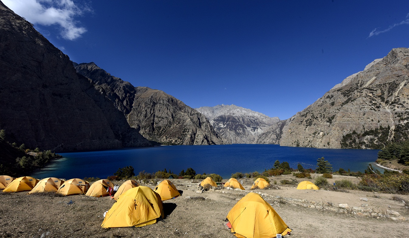
This day about 2 hours walking you will reach at Amchi Hospital. The walk goes almost entirely through beautiful pine forests, with some bushes, birches and other broadleaf trees in it as well. Before reach to Ringmo on the way you will see a spectacular waterfall of 167 meters high. After views point the path is going down for about half an hour until it gets close to the river again then walking through the forests, till you reach Ringmo. Ringmo is a charming village. People practice the Bonpo religion here. Bonpo is a lot older than Buddhism and goes thousands of years back. It has more animistic aspects than Buddhism. For outsiders it is difficult to see the difference between Bonpo and Buddhism, but one important aspect is that you have to cross their Mani walls and chortens anti-clockwise, while according to Buddhist custom, you pass them clockwise. The women wear dark or checked dresses with colorful aprons made from yak wool. You see fewer men in the typical dress, which is a long coat, from which they let one sleeve hanging down. Strolling around the village, you might see women weaving. In Ringmo women make very nice woven products, like belts, bags, shawls and blankets. Most items are made from cotton, but they also sell products made from yak wool. There are a few shops where you can buy this iteams.
Your body needs time to acclimatize to the higher ltitude. The Phoksundo Lake is such a beautiful place for a free day. There is a beautiful Bonpo Gompa (Monastery) at the shore of the lake, which is worth a visit. It’s a 20 minute walk to the monastery through the pine forest. In the monastery you can observe a statue of Thönpa Chenrab, the founder of Bonpo religion, a Buddha who lived thousands of years ago.
This day you enter the restricted area of Upper Dolpo. You follow the famous Demons Trail from the movie Caravan of Eric Valli, a beautiful movie about the life of people in Dolpa who bring their yaks over difficult passes bearing salt from Tibet to trade with grain from the lowlands. In the movie, this trail is used during this salt caravan and one of the yaks falls in the lake here. It’s a spectacular trail, going high above the Lake. At some parts it gets very narrow due to landslides. The trail climbs to a ridge, from which you have a spectacular view on the Lake, Ringmo, the dark green pine forests and the snowcapped mountain Norbung Kang (6085 m) to the south. It’s now a gradual descend to the lake northern shore, which is a good place for lunch. After this the trail climbs through a wide valley, crossing some streams. You have a splendid and nearby view to the flanks and tops of the snowcapped Kanjirowa Himal (6612m).You arrive at an alpine area which is a good place to camp.
The Phoksundo Valley gets quite narrow, with high rock walls on both sides. You have to cross a couple of streams. After about half an hour, you leave the main valley and enter a narrow gorge. It’s a long, pretty steep climb through the steep sided valley. The campsite is at Snowfields Camp, a name given by Peter Mathiesson in his famous book the Snowleopard. From here strenuous climb of about 2½ hours over a dusty path to Kang-La (5350m), locally also called Ngadra-La. There is snow most of the times, which makes a bit difficult for descending.
From here descend is pretty steep the first 45 minutes, but after this, it is going gradually for about 3 hours, till you reach Shey Gompa. Getting nearer, you pass red and white chortens and Mani walls.
Shey Gompa is a very small village, with a couple of houses, and of course the Gompa. The 11th century Gompa is located beneath the Crystal Peak on a small grassy plain, at the confluence of two rivers. It is said to be constructed by a Tibetan Buddhist, who arrived here on the back of a flying snowlion. It’s a magical place, and Shey Gompa is often called the spiritual heart of Dolpa. Every year hundreds of pilgrims come to visit the Gompa and to make a Kora (Clockwise Circuit) of the Crystal Peak. People living here are direct descendents of Tibetans, which you can notice easily by their faces and their dress. They women wear dark dresses with colorful aprons made from yak wool. Men wear a long coat, from which they let one sleeve hanging down.
During this day, you can go to Tsakang Gompa (4575m), a monastery from the Buddhist Kagyupa sect. This gompa appears in the movie Himalaya. It is spectacularly located high on a red rocky slope. The trail to Tsakang Gompa partly follows partly the same trail as pilgrims follow to make a kora of the Crystal Peak. You will probably see flocks of bluesheep in these areas. Many bluesheep live here, as the abbot of Shey Gompa imposed a ban on hunting them. Besides, in these regions you have the best chance of seeing the snowleopard.
Another pass to cross this day, the Sele-La, also called Gelu-La, of 5000m. The climb to the pass goes through a narrow valley. From the pass you have a good view to the north of the arid Tibetan Plateau, which is stretching out seemingly endlessly before you. To the east you can see Mustang. After the pass, it’s a long descend to the pastures of Namgung. Scattered in the landscape, you will see some fields. Many times accompanied with a big Tibetan tent, as the fields are too far from the village to go there and go back each day. The people in Namgung are very friendly and open.
The path goes high above the Namgung River and then descends steeply to the village of Saldang. Saldang is the largest settlement of inner-Dolpo. It’s a spread out, traditional agricultural village, surrounded by fields. Barley, buckwheat and potatoes are among the few crops that can grow in this barren landscape. Besides, people live from what the yak gives them and from trade. Saldang is close to the Tibetan border and some of the salt trade caravans pass through Saldang. The trading of salt for grain and rice is a century old tradition that still prevails in Inner-Dolpo. The people from Saldang are semi-nomadic. In the warm months they trek in the highlands with their herds of yaks and sheep. The ones who are better off let the pure nomadic people of Dolpa.
The trail follows the Nang Chu river most of the way on this wild barren windswept terrain. Walk begins along the fairly gradual path with few ups and downs slope and then passing through the small settlement of Tiling and Lurigaon till we reach to Yangier Gompa (3750m) and visit very old Bon-Po Monastery. We then continue walk to Nisalgaon where our camp set.
From Nisalgaon it is possible further past Shimengaon but to save time and energy we will walk down towards Khomagaon (4060m) which will be much easier and shorter than the other route.
After Khoma-La, fairly easy walk to Rakyo, following the Namgung Khola southwards and passing little villages, like Namdo along the way. The villages are surrounded by terraced fields of barley. The path goes alongside many Mani walls, Chortens and some Gompa’s, which makes you, realize how important Buddhism is for the people of Inner Dolpo. Buddhism is interwoven in each and every aspect of people’s life here.
The trail starts with an easy stretch, following the river. The last village you pass is Raka. After this, you enter a large, inhabited valley. Look out for blue sheep here. We steep climb to reach the Jyanta Bhanjyang (5221m). From the pass you have a spectacular view to the Dhaulagiri (8167m). After the pass you descend into the Tarap Valley.
This day we have easy walk to reach at the village Tokyu (4209), a spread out village, which is the first human settlement after Raka. Tokyu is said to be the highest visit. It has a beautiful statue of Maitreya, the Future Buddha.
It’s not far to Dho Tarap. On the way, you pass the Cristal Mountain School, which is educating children from Dho and surroundings. It is a nice school, sponsored by a French NGO. From the school, it’s about half an hour to Dho. At the entrance you pass nice a gate chorten. Also the people of Dho are direct descendents of Tibetans. Besides the typical dark dresses with colorful aprons, most Dho women wear bracelets of big shells and some have beautiful silver and turquoise headgear. Most men have long hair, with a red ribbon in their hair, in the style of Tibetan Khampas. Besides they wear the long coat, from which one sleeve is hanging down. Dho Tarap is a traditional agricultural village, surrounded by fields. Yaks are used to plough the land. As in the other villages you came across, barley, buckwheat and potatoes are among the few crops that can grow here. But nowadays, small greenhouses enable the people to grow some green vegetables as well. Besides, people live from what the yak gives them and from trade. The houses are made of stones found in the river valley and are in typical Tibetan style, with small windows and the flat roofs stocked with firewood. Close to Dho are 2 monasteries which are worth a visit. Ribo Bhumpa Gompa, right on the hill behind Dho, and Shipchaur Gompa, which is in the village Shipchok, 30 minutes walking from Dho. Ribo Bhumpa Gompa belongs to Nyingmapa Buddhism, by the local people called Chöba Buddhism. Inside you find a beautiful big statue of Guru Rinpoche. Guru Rinpoche (Padmasambhava) is a very important Buddhist saint from the 7th century AD. He conquered the demons that were preventing Buddhism to get hold in Tibet and in this way made sure that Buddhism could be introduced in Tibet. You can easily recognize him, by his big eyes, little mustache and the staff with skulls he holds. Next to the Gompa is a chorten with a chorten inside, which is said to hold the remains of a demon killed by Guru Rinpoche. Shipchaur Gompa in Shipchok belongs to Bonpo Buddhism.
Leaving Dho Tarap, you come along many Mani walls and small chortens. The path is going down, following the Tarap Khola. Gradually you can see the landscape changing. After leaving Sisaul, you climb to a small pass with a nice chorten. You mostly walk in the river valley with high rocks towering above you on both sides. The landscape is still pretty barren and this is your last change to see the bluesheep or snowleopard. The path gradually goes down, with some parts going up as well. At some parts the path is beautifully carved out of the rock, so that you are walking in a kind of three sided tunnel and rech at Nawarpani.
After Nawarpani, the landscape gets quickly greener and the path is sometimes going through pine forests, with a wonderful smell. It’s a fairly easy walk over a pretty large path. The path sometimes goes very high above the river. The path goes along the east and west side of the river, crossing the river twice by suspension bridges and we reach at Laina Odar, located at the riverside. From Laina Odar the trail goes down pretty steep to Laisicap (2772 m). Although the trail is generally in good condition, there are a couple of landslide areas where the trail gets very narrow, and where passing is a bit difficult. The landscape is very beautiful. The path goes partly through forests and you are surrounded by steep cliffs full of pine trees, mostly spruce, fir, juniper and cypress, some of which are huge
Early morning, a short scenic flight for thirty five minutes to Nepalgunj, over the Himalayan foothills overlooking stunning views of the main peaks including Annapurna and Dhaulagiri to the north. On arrival at Nepalgunj depending upon the connecting flight schedule to Kathmandu. If it is in the afternoon have time for few hours’ refreshment in the comfort of the Hotel Batika or similar at Nepalgunj. Then connect with the flight back to Kathmandu.
This pleasant day you may have full day at leisure and either relax at hotel or explore the Thamel and overnight at hotel.
After breakfast you will have some free time until the time to leave the international airport for your final departure.
After breakfast you will have some free time until the time to leave the international airport for your final departure.
Cost Included
- Documents: Upper Dollio special permit, National liark entrance permit
- Activities: Sightseeing, hiking and trekking trilp as per itinerary.
- Equiliment: All necessary campiing equiliments and kitchen utilize
- Accommodation: 4 nights hotel in Kathmandu, 1 night hotel in Nepalgunj on twin sharing bedroom and 21 nights camping on twin or multi shared tended during trekking
- Food: Full board on campiing (Breakfast, lunch and dinner) during the trekking and 5 breakfast in city.
- Staffs: Leader/Guide and supporters and their daily wage, food, and accommodation
- Transliortation: All airport arrival/departure transfer and surface road-head transliortation and Kathmandu to Nepalgunj and Jhupal and return flight to Kathmandu
- Company and Government’s service charge: All applicable Government taxes and official service charges. And Crew’s, daily wages/salary, food, equilpment, air and road-head transportation
Cost Excluded
- Your international flight
- Travel/medical insurance coverage personal accidents, medical and emergency Helicopter rescue
- Personal travel and trekking equipments
- Lunch and dinner while in city
- Items of a personal nature such as normal drinks, hot shower, dessert, laundry, internet and phone call.
- Expenses occurred due to unavoidable Events i.e. road wrecks, flight delays etc.
- Tips/Gratuities for your trekking crews
- Temple and Monastery entrance fees
- Optional activities
- And unforeseen expenses which are out of control by Nepal Adventure Point
Trip Notes
Please request our Trip Note advice and detailed itinerary.